To get a list of topographical maps that cover a particular area, drag the orange map icon to your point of interest then click the "Find Maps" button. You will be able to download your map on the next page. The 2025 NCKMS Symposium's map database currently contains 258,252 maps. The catalog was last updated on Friday, May 17, 2024.
![]() Bristlecone Convention Center
Bristlecone Convention Center
![]() Great Basin NP
Great Basin NP

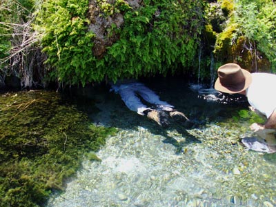
Gandy Warm Springs is a refreshing oasis of tiny waterfalls, pools, caves, and crystal clear streams with water temperatures up to 81°F. Located on the western edge of Snake Valley, near the Nevada border, the springs are at the base of the southern tip of Spring Mountain (also called Gandy Mountain). The spring water that cascades down the slope of Spring Mountain joins a larger spring that emerges from a cave.
Advance registration for the 2025 symposium is expected to open in mid-2024. We will send an email to past attendees when that system comes online.
Feel free to join our mailing list if you would like to receive occasional updates on our plans.